Friday, September 26, 2014

Natchez, Part 4

Sunday, September 22nd


Today was church in the morning.  We attended Trinity Episcopal Church on Commerce Street.  This is the oldest church in Natchez.  Four of the stained glass windows are not only original Tiffany windows, they were also installed by Mr. Tiffany himself.  Pictures of the windows can be seen here.

From there we drove out to the Natchez Trace Parkway.
 
 Various parts of the original Trace are still visible along the Parkway.  The Trace was originally a series of trails used by local Native Americas, then became a trail north for people who had brought goods down the river to sell and were traveling home.


 Emerald Mound, the second largest Indian Mound in the United States.  The largest is found at the dig at Cahokia, across the Mississippi from St. Louis.


 The bluff on the left side of the photo contains soil that was deposited during the Ice Age, but has become eroded due to wind and rain.  This causes parts of the Trace to become sunken.

 
Mount Locust, an inn along the Trace.  It's located about 15 miles from Natchez, and housed travelers using the Trace to go north.

One of the rooms at Locust Point, complete with a set of child's dolls and a hat.

Implements and shoes/boots that would have been used in the 1800s by people staying at Locust Point.


Tuesday, September 23, 2014

Natchez, Part 3

September 21, 2014

We finished with the plantation early enough that we had time to return to Natchez and visit the Grand Village of the Natchez Indians.  Website is here.

This is a small park with a museum, three earth mounds and a replica of the Indians' homes.  Like many tribes along the Mississippi, the Natchez built mounds.  Often they built homes or temples on the mounds, although some mounds were used for burials. 

Archaeologists have excavated two of the three mounds here; the third one apparently wasn't used much by the locals, as it kept washing away.  It's been left for future excavations.


This is the larger of the two remaining mounds, and was used as the base for a temple, as well as burial.  French traders recorded two funerals in this village.  Both were for chiefs, or "Great Suns", and both involved human sacrifice of the chief's family and some servants. The second mound held housing for the Great Sun and his family.


Inside the museum are displays of pottery, hunting implements, and a history of the area.  There is also a place hosting items visitors can touch, such as feathers, stones, and pieces of pottery.


The replica of a Natchez house.


Plaques around the area provide information on the culture and history of the Natchez.  All of it is on level ground, and walking is easy.  Most of the grounds can be covered in half an hour or so.

There is also a picnic area, which doubles as a spot for community groups and families to hold events.  While we were there, the local Humane Society was wrapping up an annual fundraiser, and later several families set up for a Frozen-themed birthday party.

Natchez, Part 2

Saturday, September 20th


We of course have a list of things to see and do.  We decided to start with the places farthest away, so this morning we visited the Frogmore Cotton Plantation in Frogmore, Louisiana.

Website here: when you first log on, people are singing about picking cotton.  The song stops after 30 seconds or so.

The plantation has several tours; we took the Old Fashioned vs. Modern Day tour, which basically walks you around the plantation while the guide explains the purpose of each building and various facets of life in the 1800s and 1900s.  Our guide could actually sing and everything.  We found out later that she had a college degree in music and also produced the videos we watched.

I have a video of some of the buildings on the grounds.  No singing, though.


Just a few general pictures of the insides of buildings:

 Above: the laundry building, where clothes are cleaned, pressed, and sometimes made.  Yes, that is a quilting frame.


 The overseer's house.  This sometimes belonged to a white hired hand, but often belonged to one of the slaves who kept the others in line.  The house boasted a breeze along the front and back porches, and better quality furniture.

 Sacks for the harvested cotton.  Sacks held about 70 pounds of cotton, and slaves frequently picked between 250 and 350 pounds a day.
 The 3-hole privy.  This time period was long before indoor plumbing....


 A typical bed for a slave.  Mattress was stuffed with moss.


Planting machines in the "modern" era.  The one in front is a John Deere.

Part of the tour was a video showing current cotton farming practices.  No more slaves, thank goodness.  Now the work is done mostly by machine, which bales up the cotton the same way other farmers bale hay.  The seeds are purchased each year from a company and planted; the seeds the cotton plants produce are made into various products, like Crisco.  (Which stands for CRystalized CottonSeed Oil.  Been using the stuff for years and had no idea.)

Another part of the tour was the opportunity to pick a boll of cotton ourselves.  Free souvenir!


Sunday, September 21, 2014

Natchez, Part I

So, this year's get-away is Natchez, Mississippi.  My first real vacation in two years.  If you haven't heard an account of last year's Misery at the Library, consider yourself lucky.  I won't talk about that here.  I am, after all, on vacation.

Mom and I boarded Amtrak in Syracuse on Wednesday, September 17th.  As usual, the train ran late.  By the time we got up the next morning, it was FOUR HOURS late.  Some of the folks riding with us barely made their afternoon connections.  We thought we were going to have just enough time to grab lunch and board our train, but discovered at the station that the schedule had been changed, and we still had a five-hour layover.  (We are seriously considering taking a Chicago city tour on our return trip, as we will have a nearly 12-hour wait, assuming the train is on time.  Yeah, right.)

We were about 25 minutes late getting into Brookhaven, MS, where we had reserved a car.  The station master was a little put out at this; he expected us to be in by 12:30 or so.  The station is open twice a day: from 11:30 a.m. to 12:30 p.m., and from 3:30 to 4:40 p.m.  That's when the trains pull in traveling south and north, respectively.

We contact the Herz rental office, and a nice young man drove over and picked us up.  I then signed the rental papers, and we were given a larger car than we had asked for, since the car they wanted to give us wasn't ready.  (No complaints -- the car we have handles beautifully.)

We headed south to Natchez, and managed to find the Visitors' Center, which doubles as the National Parks office as well.  Bonus!  Picked up maps and brochures, got information on tours, and got directions to our hotel.  (For some reason, the GPS has no idea what hotel I'm talking about.)  Oh, and we found out why it was so difficult to get rooms this weekend -- there's a HOG convention in town.  HOG=Harley (Davidson) Owners Group.  Yup, motorcycles everywhere.  All weekend long.  Yee-haw.

Will post more when I start getting pictures uploaded.

Thursday, December 13, 2012

Georgia, Part 6

Actual date,Sunday, December 9th.

Oh, wait, we DID get to visit Kennesaw Battlefield after all!

We finished up at the Harris house around 1:30 in the afternoon, and since the battlefield didn't seem that far away (about a 40-minute drive), we decided to add it to the itinerary.


Kennesaw is on the outskirts of Atlanta, and was  the first position used by the Confederate Army, led by General Joseph Johnson, to delay the advance of General William Sherman's Union Army.  The battle was fought from June 19th to July 2nd, 1864.

The battlefield has four areas; the Kennesaw Mountain artillery position, Pigeon Hill, Cheatham Hill, and Kolb's Farm.

A shuttle will take you to the top of the Kennesaw Mountain position, or you may walk the road.  There is also a steep hiking trail.  Naturally, we rode.  Above is a picture of the cannons and fortifications at the top of the mountain.  Confederate and Union troops traded cannon fire for nearly a week, but neither seemed very effective.

The next part of the battlefield was down the road at Pigeon Hill, but that site was a hike into the woods, and we were running out of daylight.  So we skipped ahead to Cheatham Hill.


Cheatham Hill was the "bulge" in the Confederate lines, and became a focal point of the battle.  The Southern army erected barriers and dug trenches.  They also camouflaged a set of cannons, with gunners given the order not to fire until specifically told to do so.

There are two kinds of plaques on the battlefield: the "slate" markers, seen at right, and a "table" marker common to National Park sites.  The "slate" markers usually present a single person and his contribution to the battle.


Cheatham Hill saw the bloodiest fighting of the battle.  Union troops made several attacks and were repulsed each time.  Finally a Confederate colonel, William P. Martin, called a cease-fire and instructed troops on both sides to come and remove their fallen comrades.  The next day, Union commanders presented Martin with a set of pistols to thank him for his humanitarian act.

Several monuments stand in the park, commemorating various regiments who fought here.  At left is the Illinois Monument.


The cannons above represent the hidden cannons.  They remained silent for over a week before the order to fire was issued.  The battle actually raged around them.  When they did fire, however, they were shooting into the middle of Union troops, and proved to be very effective.


Kolb's Farm, pictured at left, was actually the opening scene of the Battle at Kennesaw.  Confederate cavalry repulsed Union troops.  Sherman wanted to bypass the area and proceed to Atlanta, but later decide that Confederate troops were spread so thin that an attack would cripple the Southern Army.


The farm house, pictured above, was eventually purchased by the National Park Service and restored to its 1860s appearance.  Now it houses offices, and is not open to the public.  If anyone wants to check out the NPS Kennesaw site, click here.

Wednesday, December 12, 2012

Georgia, Part 5

 Actual date: Sunday, December 9th


We had planned to visit the Kennesaw Battlefield, but opted instead to travel to The Wren's Nest, the home of author Joel Chandler Harris, best known for his Uncle Remus stories.

The site is named for the fact that birds used to (and apparently still do) build nests in the Harris' mailbox.

The house is pictured at right.  For once, we caught a break; December 9th is Harris' birthday, so the site is not only open on a day it's normally closed, but there is also no admission.


If we wanted, we could stay for storytelling sessions, but we were mostly interested in Harris' biography and a tour of the house.  At left is the harp player in the front parlor.  The schedule of events was posted as follows:

"Tours every hour, history every half hour, cider available throughout the day, harp playing intermittently, or whatever actually happens."


At right is the family room, with a round table decked with a wreath for Christmas.  If you have very good eyes, you can just make out the picture of Br'er Rabbit on the chair behind the table.  (If you don't have good eyes, join the club.  And ask to see our trip photos when/if we get home.  I have a much better version of this photo on my laptop.)


 For the official website, click here.


At left is the dining room.  Harris and his wife had nine children, six of whom survived to adulthood.


Below is the girls' room, where the daughters slept.  Like the rest of the house, this room is decorated for Christmas in the style of the 1870s.


Joel Chandler Harris and I shared a birthday together.  He would have been 167.  I turned 51.


By the way, lunch today was at the Q-Time Restaurant, which had a cafeteria-style service and seating.  Roast chicken, ribs, beef tips, and vegetables.  If you go home hungry, it's your own fault.  It's right down the street from the Wren's Nest.


Georgia, Part 4

Actual date, Sunday, December 9th

First order of business, go to church.  We attended Corpus Christi Roman Catholic Church in Stone Mountain.  Anyone who doesn't believe in "the browning of America" needs to go to mass here.  It's a regular United Nations.  Most folks are quite friendly, however.

This video is from the small garden display at the front of the church.


Georgia, Part 3

Actual date, Saturday, December 8th.

If you ever plan to go to Atlanta, Georgia and ride the public transit system, e-mail me first.  I can save you a HUGE hassle.

Round trips on both the local buses and the local train are $5.00.  You can pay cash for the buses if you prefer, but the train requires a Breeze pass.  You have to buy one at the station before you can get through the gates to get to the train platform.

Presumably there is an easy way for Atlanta residents to find this out.  The only reason we discovered it was because after several minutes of us standing at the gates trying to figure out how to get in, an employee of the system walked over and explained it to us.  So we each had to purchase a pass, load $5.00 on it to get into Atlanta and back, and then actually get through the station to the trains.

Before all this, however, we had to catch the bus to the train station.  After we had walked five miles yesterday looking for the bus stop, we drove back to Stone Mountain Village, parked the car, and walked to the bus stop.  The bus pulled up about seven minutes later.

Ooops.  We were on the wrong side of the road.  We needed to be at the stop across the street to go into Atlanta.  This bus was coming out of Atlanta.  So we crossed the street and the next bus came by.  We got on and paid the driver.

The bus ride was probably 25 minutes long, and it dropped us off at the train station, which provided yet another 20-minute ride to the Dome, the local sports arena.  We got off the train, but couldn't get OUT of the station.  The doors wouldn't open.  We were supposed to tap our pass on a pad to get out.  Finally, due to a complete lack of other options, we did this.  Then I used one of the local pass machines to scan the card.  Instead of the $2.50 that should have been on there for our return trip, the card balance read zero.

So it cost $2.50 to take the train to Atlanta, and $2.50 to get out of the station.  We had to reload all three cards with $2.50 each to get back to the bus.  While we were doing this, another woman walked up and asked if I understood how these machines worked.  She had a handful of coins and her pass; this was the change she had received.  I explained that those were dollar coins, and that it really was valid currency.  She was quire relieved.  The only reason I know this was because not only had we gotten a bunch of the coins ourselves, but I had seen dollar coins in other places a few years ago.  I have one at home because they are such a novelty.

So, we walk up the steps into the entrance of the arena, then up the ramp to the sidewalk.  We're looking for the Coca-Cola factory, which used to be right near the train stop.

No such luck.  After asking around, we discovered that the factory was three or four blocks away.  The only way to get there is to walk.  We hiked through the Olympic memorial park, which is at least two blocks long itself, and finally find the factory.  There is a $16 admission fee for adults, $14 for senior citizens.   Then we have our bags searched at the door.  The staff does provide a wheelchair for Dad, but it's a manual.  The reason there are no photos on this entry is that I was busy pushing the wheelchair.

Mom has fond memories of this factory tour, but it's all changed, unsurprisingly.  We have a staff member show us some of the Coca-Cola memorabilia from down the ages, and then we watch a six-minute movie about living a good life.  What this has to do with creating a bottling Coca-Cola completely escapes me, other than the fact that bottles of Coke do appear in the movie.

If you want to experience the whole thing on the small screen, it's on Youtube.  Honest!  Try here.  If you figure out the point of the movie, let me know.

Then it's out the door for one of several exhibits.  One is a history of the beverage, invented by a pharmacist in 1886.  (Complete history is described here.) Another display is the actual bottling of the beverage in glass bottles that visitors take home at the end of their tour.

A lot of space is dedicated to the "secret formula" that has changed hands a few times and has been imitated but never duplicated (according to the display, anyway).  The whole exhibit is housed in a "vault," and there is a place for people to try their hand at creating "formulas" of their own.  Impossible to get to through the crowd of kids and families.

After all that, you can go upstairs and get your picture taken with the Coca-Cola Polar Bear (for a fee, of course), and proceed to the main event, sampling a variety of Coke products produced in various parts of the world.  Just for the record, we liked the "Fanta Magic" beverage produced in Estonia.  It tastes as though they're trying to make wine out of it.  There was also a peach beverage from a location in Europe that I don't remember.  I think the least favorite was the beverage from Italy.  The almost universal reaction was for people to sip, frown, grimace, and pour the rest of the sample down the disposal grill.  Mom complained she could still taste that one 10 minutes later. 

The newest taste is a gingerbread Coke that you make at home from ingredients available at select stores.  The person serving the samples didn't specify which stores those might be.

Finally, we pick up our free bottles of Coke, walk through the gift shop without buying anything (the prices were high, of course), and drop the wheelchair off at the front gate.  Then we had the walk back to the train station.

Our train took us up about three stops, then the conductor announced that the train was "out of service" and everyone had to get off.  We waited another 10 minutes or so for the next train, but since we hadn't left the platform, we could bet back on without paying a second time.

Once back at our station stop, we managed to exit by tapping the cards again.  For a wonder, it actually worked, even though we had no money left on any of them.  This has got to be one of the weirdest transportation systems on the planet.

We finished the day at a German restaurant in Stone Mountain Village called The Village Corner German Restaurant and Bakery.  Good, but expensive.

Then it was back to the hotel.  By the way, we still have the Breeze passes if anyone ever wants to use them.

Monday, December 10, 2012

Georgia, Part 2

Actual date: Friday, December 7th.

Off to Stone Mountain to the Confederate Memorial.   There's a whole park dedicated to this.

It's $10 admission to the park, which consists of the stone monument, a museum, a grist mill, various hiking and bicycle trails, and a skyride to the top of mountain to get a closer look at the monument.  An additional fee of $12 will get you a round trip on the skyride and admission into the museum. 

I'm about to save you $22.  You can thank me later.

Above is a photograph of the monument.  It depicts Jefferson Davis, Robert E. Lee, and Stonewall Jackson on horseback.  It was started in 1923 by Robert Borglum, the carver who later designed and completed Mount Rushmore.  (Yes, THE Mount Rushmore.)  He worked on it for a year, had a disagreement with the management, and left, taking all notes and sketches with him.

A second carver, Augustus Lukeman, took on the project, but by the deadline year of 1928, he had only one figure's head completed, and was out of money.  The family who owned the property reclaimed it, and no work was done on it for nearly 40 years.

Work finally began again in 1964, and this time the project was completed.  If you want the entire story, follow this link.

That's it.  We skipped the grist mill (seen 'em), the museum (seen those too), and since it was a Friday in winter, there wasn't anything else going on at the park.  We weren't about to come back the next day and pay another $10 just in case something interesting might be happening.  Besides, we were planning to take the bus into Atlanta to the Coca-Cola factory for the day.

More fun ensued.  We had to find a bus stop.  We had asked at the front desk of our hotel.  The clerk was a nice young woman, but had no idea where (or if) the bus stopped anywhere in Stone Mountain.  She sent us off down the road looking for an unmarked building.  No luck.  One of the local shopkeepers finally told us the bus didn't stop in that part of town any more.

Next we tried the library in Stone Mountain Village, which is outside the park/monument.  The clerk thought the bus stopped on Fourth Street and that there was parking there.  So Mom and I walked over.  The lot was closed off.  We stopped at the bank, and the teller thought the bus stopped on Second Street.  There were no signs of any bus stop there.

We finally asked someone at an antique store, who very helpfully pointed out the bus stop sign two blocks up on the right -- ironically enough, a block up from the library's parking lot.  In the other direction from which the clerk sent us.  Okay, we were in business.

Or so we thought.

Georgia, Part 1

Actual dates: Thursday, December 6th and Friday morning, December 7th.

Someone remind me again why we think we enjoy this stuff?

This trip is already a heavy-weight contender for "Worst Vacation Ever," and we aren't even in Georgia yet.  We arrived at Penn Station in Philadelphia early (thanks, Jim!), picked up tickets, and asked a station Red Cap to help us get our bags to the lounge to wait.  He can't.  We aren't sleeping compartment passengers.

Say what?!

When we actually checked the tickets, we discovered he was right.  Instead of having the handicapped compartment in the sleeping car, my parents had the handicapped seating in the coach section.  This means sleeping sitting up all night and sharing the car with 40 or 50 other people.

Mom attempted to get this straightened out at the ticket window.  The agent told us all the sleeping compartments were sold out and there was nothing he could do for us.  Then we went to customer service.  The agent made a call to headquarters, and Mom got precisely nowhere.  All compartments were sold out.  Finally we decided that my parents would sleep in my room (I did have the correct sleeper accommodations), and I would travel in coach.

Oh, yay.

Not.

God bless the fellow who took our bags up to the lounge.  He asked the train conductor about finding a sleeping compartment at any point along the route.  Thanks to him, I traveled in coach until the train arrived in Charlotte, North Carolina at 2 a.m., and then transferred to an open sleeping compartment for the rest of the trip.  So I did manage to get about four hours of sleep before we pulled into Atlanta at 7:50 a.m.  You better believe he's going to get a letter of commendation from me when I get home.

In all fairness, things weren't bad in coach.  There were four children in my car, and I only saw one of them.  I didn't hear any of them.  Everyone pretty much politely ignored everyone else, so there was some semblance of privacy.  It wouldn't be a bad way to travel if it were just for a few hours during the day.  Trying to sleep in there at night is a whole 'nother story.
And dinner was very good -- roasted chicken with vegetables.  Of course, I had to pay extra for it, since I was a coach passenger, and I was interrupted in the middle of dinner by the conductor, because he needed to scan my ticket, which was four cars back at my coach seat.

But we did finally get into Atlanta, picked up the bags and our rental car, and got out of town.  The first three nights are booked in Stone Mountain, Georgia.

And the "fun" continues....

Tuesday, May 29, 2012

Colorado, Part 8

Durango and Silverton were two of our final touring destinations.  They are linked not only by road, but by rail with what's known as a "narrow gauge" track.  Mom and Dad rode the train from Durango to Silverton and back, while I took a jeep ride into the mountains around Silverton to explore ghost towns, streams, and mines.  But first, some of the scenery on the bus ride out to Silverton.


Much of the scenery was like this.  These are the San Juan Mountains, by the way.


This is shot out the bus window at the road we would be riding in another minute or so.  Much of it was again twisty and winding.  I'm convinced that the state motto is actually: "Colorado -- where guardrails are for wimps."
Straight down as we round a curve.  Mom had originally planned for us to drive this road to Durango, but chose another route after she found out about the lack of guardrails.


The bus that carried us to Silverton.  The company is called Mild to Wild, and they offer several package tours coupled with the train ride.

And this is the "jeep."  Actually, the company did have a jeep-like truck that they were supposed to take us around in, but when our bus driver's brother started it up that morning, he discovered someone had pour sugar in the gas tank.  So we drove around in a couple of alternate vehicles.


A rock-crusher built into the side of a mountain.  Stone containing metal ore was dropped down this set of stairs, breaking the stone up for easier extraction of the gold, silver, or other metal.  The stone was then shipped to Durango for processing.  The technique apparently couldn't be done in Silverton -- the altitude was so high that fire couldn't be made hot enough to melt the ore.


A long, long stream of waterfalls.


One of the ghost towns in the area. 


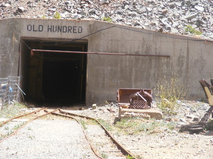
Area gold mine.  You could take a tour and visit a small exhibit on how gold and silver are mined.  There are still a number of mines in the area that could be worked, but people have a hard time getting permits because of environmental constraints.

People on the jeep ride with me thought that was terrible and the government shouldn't be allowed to do that.  Sorry, folks, but I'm with the EPA on this one.  My clean drinking water trumps your mineral rights.  Or it should, anyway.


I rode from Silverton back to Durango on the same train my parents took.  They got the luxury accommodations.  I got to travel coach, since I was only riding one way.  This is my car, from the back.


If you didn't mind the wind, you could also ride in the open observation car.


Mom and Dad "de-train" in Durango.


Much of the rest of the trip was shopping and traveling to different locations on our way back to Trinidad to catch the train on Friday evening.  We were concerned about the 45-minute wait at the "station" because there really wasn't a station.  It's just a loading platform and parking lot right now.  (Apparently it's just been upgraded.)  However, there was a sort of shelter at one end of the platform, so we could get out of the wind and sun.

Also, for the record, I picked up four Christmas gifts on this trip.   :-)

And now for a our last "wave," to Jonathan and Cheryl at the bank:


And that's it, until the next trip in September.  Tune in for yet another jaunt to Gettysburg, PA.


Monday, May 28, 2012

Colarado, Part 7

May 22, 2012

Mesa Verde National Park roads seem designed to frustrate people.

We drove 15 winding, twisty miles over mountains to get to the visitors' center and our tour bus.  It's got to be the longest 15-mile drive on the face of the Earth.

Mesa Verde includes 80 square miles of Anasazi cities, inhabited in the 1200s. The word "Anasazi" means "ancient enemy" in the Navajo language.  Although there's been a movement to change the name to something a little more accurate, most of the suggestions have been unwieldy.  Plus, a number of tribes are weighing in on the name change, and can't seem to agree on one.  So our guide used "Anasazi" throughout our tour.

Many of the cities look like the one on the right, tucked under an overhang called an alcove.  They consist of round rooms called kivas, and square homes, many with towers.  Kivas were the rooms in which religious ceremonies were held.  They were also sometimes used as dormitories when no ceremonies were being held.

Our tour was offered through Aramark, a lodge in the park itself, and lasted over three hours.  Our guide took us around to view several sights, with two stops to get out and talk about the culture of the Anasazi. 

At left is our tour guide talking about the yucca plant.  It was (and in some cases still is) used as a source of food, fiber for weaving, the basis for soap, and the soles of sandals.

Our guide also talked about the juniper tree, which is used for a variety of items, including building materials, firewood, food, and decoration.  


 At right is a double-tier city.  Many of the sites are off-limits to visitors, but we got to actually walk into Cliff Palace, one of the largest of the ruins.  It is pictured below.

The cities are made of stone bricks mortered with clay mud.  Most of the cities seem to have been building in a 30-year period.  The Anasazi originally lived on top of the mesas, and then in the early 1200s, began building cities in the alcoves.  Theories about what caused the moves include greater access to water supplies, protection from enemies, and shelter from increasingly poor weather.

Left: Cliff Palace.  Our guide for this was actually a National Park Ranger.  The site is not even remotely handicapped accessible -- you have to be able to climb down 130 steps (some metal, some stone), and up three ladders (about 10 feet long).

Plus the atmosphere is much thinner here, as we were at 7000 feet.  (Sea level is around 5000 feet.)

Still, if you can made the trek, you can actually walk around the plaza that connects the houses and kivas.
At right, if you look closely near the bottom of the picture, you can see a series of logs protruding through the wall.  These logs make up the wooden floor inside the building.  They were cut with hand-axes, giving them a "gnawed" look on the ends.  Several of the houses had more than one level; the tallest building were four stories high.

When you stand next to the doorways of the houses, you realize that the average height of people back then was under 5 feet tall.  Our guide mentioned that that seemed to be pretty universal among people living in the 1200s, no matter where on Earth they lived.

For many years, there was a mystery surrounding the disappearance of the Anasazi.  By the end of the 1200s they had all left the area.  Theories included being chased from the area by enemies, or even alien abduction.  But anthropologists noticed similarities between Anasazi culture and the cultures of the Pueblo and Hopi Indians.  It's now know that the Anasazi moved to a different part of the Southwest and continued their civilization elsewhere. Their descendents are still living on those areas today.


Saturday, May 26, 2012

Colorado, Part 6

Saturday, May 19th

Not a lot to report here.  I spent part of the day going whitewater rafting on the Arkansas River, through a section rated as Class 3.  (No large waterfalls, and a better-than-average chance of surviving the experience.  :-) )  I have no pictures to post, since my camera isn't waterproof.  My trip was done through Performance Tours, and lasted a couple of hours.

Sunday, May 20th

We attended church last night, but went back this morning for a quick "wave" to Barbara and Gary Vining:


Sunday, May 20, 2012

Colorado, Part 5

Pikes Peak, and the cog railroad that goes to the top.  (Thank goodness.  I'd hate to have to hike that....)  (And, for the record, people don't just hike it, they run marathons up and down it.  No joke.  The record to the top and back is just over three hours.  You can also drive to the top.)

Pikes Peak is the inspiration for Katharine Lee Bates' well-known song "America the Beautiful."


One of only a handful of cog railroads in the United States, this is the longest and climbs the highest.  As you can see in the picture on the left, there is a "third track" in the center.  This is where the gears on the underside of the train connect, and literally pull the cars up the hill.  (The two outer tracks are for balance.)

This railway was started in 1889, after a tourist named Zalmon Simmons road to the top of the mountain on a mule, but decided there had to be an easier way to get there.  He raised over $1 million to build the first set of tracks, which were used by steam engines.  Of the six original engines, only one still operates on special occasions.  The first diesel cog engine was used in 1938.

Here's the actual train itself.  The trip up and back takes around three hours.  You spend half an hour at the summit, where there's a gift shop and a set of rest rooms and observation platforms.  The conductor gives information about the vegetation, local activities, and the history of the railroad as you ride to the top.  There's often a 30- or 40-degree difference in temperature between the bottom depot and the top.  Also, it's a good idea to bring along a can of oxygen (sold in the gift shop) if you or someone in your party has trouble breathing.  After all, you're going up to over 14,000 feet above sea level -- air's pretty thin up there.  (The poor fellow across the aisle from us had such a hard time adjusting that he threw up when we reached the top.)  It's not unusual to need to sit down and drink something for the first 10 minutes you're there.  Also, because of the change in atmosphere and air pressure, your voice changes.

Below are some of the sights we saw on the way up.


Some of the trees look tilted.  Actually, they're growing perfectly straight -- we just rode up at an angle.  And that line across the middle of the picture is the top of our window.

Below is a video shot at the top.  The wind covers up a lot of other sounds, so my narrative may not be audible at all times.  Basically, it's about 40 degrees F, with a wind-chill factor of 20 degrees.


And below is another of Mom's "waves", this time for Jeff.  We're at the summit of Pikes Peak.