Tuesday, November 29, 2011

Alabama, Part 3

 On to the city of Montgomery, and the Hank Williams statue, museum, and grave site.

The statue, left, is supposed to be life-sized.  Mom and Dad give it some perspective.  (Yes, it's raining.  And chilly.)

We also attempted to find the restaurant/hamburger place where Williams liked to eat, but were informed it had burned down a year ago.


The museum lobby, including a display of photos of people with whom Williams worked.  Photos were not allowed inside.


One half of the grave site, just outside of the city.  Hank Williams is buried on one side, Aubrey (the first wife) on the other.  Below is a video so you can see the whole thing.


Monday, November 28, 2011

Alabama, Part 2

Our next stop was just down the road and over a couple of hills at the Tuskegee Airmen Museum.  These were African American men who wanted to fly for their country during World War II, but were banned from doing so by law.  Finally, a program was started at the Moton Air Field in Tuskegee, and in 1942, the first group of trained pilots, bombardiers, and navigators were ready to serve.

The museum pays tribute to everyone involved in the training: recruits,instructors, intelligence officers, technicians, and support staff.  After watching a four-minuted video, visitors could walk into the hanger and take a self-guided tour.

At left is a wide view of half the museum.  Note the parachutes hanging from the ceiling; there were three staff members who packed and checked the chutes -- all of them were women.  There is actually a hands-on parachute station at which visitors can try their hand at this job.  It's not easy!


At right is a practice console used in training.  Navigators and pilots were expected to be able to fly using only their instruments.  Below is the simulator, provided by Link Aviation.  Yes, the one outside Binghamton, NY.  Mom is sitting in the cockpit.  She worked for Singer-Link for six years in the late 1950s.


The exhibit features recordings of actual base personnel, including the trainees, intelligence officers, mechanics, secretaries, and others. 


At right is a restored Piper Cub, one of the planes used for training flights.


Since both this and the Tuskegee University sites are run by the National Park Service, I could get my NP Passport book stamped in both places.  Also, admission was free in all areas (although donations were cheerfully accepted).

Sunday, November 27, 2011

Alamaba, Part 1

Got off the train in Birmingham, rented a car, and drove off to Montgomery.  Our first stop was the Tuskegee Institute National Historic Site, which includes Tuskegee University, the George W. Carver Museum, and the home of Booker T. Washington, who served as the university's president from 1881 until his death in 1915.

 We started in the Carver Museum.  George Carver was born a slave in 1864, near Diamond, Missouri.  At one week (yes, one WEEK) of age, George, his sister and his mother were kidnapped and sold in Kentucky.  The Carvers, who originally owned George's family, hired a man to located the kidnap victims, but George was the only one who could be found and returned.  George and his brother James were eventually adopted by the Carvers after slavery was abolished.  George showed an interest and aptitude for natural sciences, especially botany, and his parents encouraged his interests, sending him to school 10 miles away in Neosho.

As he grew older, George continued to seek education wherever he could find it, often doing menial labor to support himself.  He eventually gained fame as a botanist (although he also loved to paint).  In 1896, Booker T. Washington invited Carver to head the agricultural department at Tuskegee Institute.

The campus houses an entire museum dedicated to Carver's work.  His greatest interest was in teaching practical knowledge that could be used to make a living, so that people of African descent could achieve equality with their white neighbors.  Carver taught mostly farming techniques, but also experimented with weaving, pigments for paint, and processing of crops such as sweet potatoes, cotton, and, of course, the peanut.

 At left: Carver's mobile classroom.  He often loaded displays and tools into this vehicle and drove to communities to talk directly with farmers who couldn't attend his school.


At right: pigments of paint that Carver developed.  Some could be used to paint houses, others were for decorative work like his painting below, "The Peaches".  This is the original painting, one of the few survivors of a fire that destroyed some of his other works.  The colors have become muted due to smoke and water damage.

By the way, George Carver never actually used the middle name of "Washington" himself.  He added the W. initial while attending one of many schools, because there was another "George Carver" there.  People asked if the W. stood for Washington, and he answered, "Why not?"  He himself used only the letter.


At left is a painting of Booker T. Washington, and his home, The Oaks, was the next stop on the trip.  The house was built in 1899, and was meant at least partially as proof that African Americans could live just was well as whites.  The house had the most modern anemities Washington could find -- indoor plumbing, lighting, even a sauna.  Like many of the buildings at the Tuskegee Institute, it was built by students of bricks made on campus.  Many of the furnishings were also made by students and other local crafters.


Pictures are allowed inside as long as a flash isn't used, so I do have this photo of Washington's study.  The ornate chair was carved in China and shipped here as a gift.

Many of the furnishings are period pieces, not authentic to the house, but most of the items in the study did belong to Washington.

According to our tour guide, Washington was meticulous about details and demanding of his employees.  Often students would train with him to become housekeepers, one of the few jobs in which African American girls were accepted.  Washington insisted on a scrupulously clean house, and several fresh shirts in his office each day -- every time he began to sweat, he would change his shirt.  Of course, in Alabama, sweating is expected, especially during the summer.


Friday, September 30, 2011

Massachusetts, Part 3

Still in Salem.  One of the other things we did is walk through the Old Burying Ground, more commonly known as the cemetery.  At certain times of the year you can get tours, but the area itself is open during the day, and visitors can stroll through at their own pace.  A list of graves and related information can be found here.  Another website, providing brief paragraphs on the people buried in the cemetery is here.

The cemetery was started in 1637.  Some of the better-known "inhabitants" include John Hathorne, the "Hanging Judge" who ordered the convicted witches' executions; Governor Simon Bradstreet, husband of poet Anne Bradstreet; and Samuel McIntire, an architect who designed many of the mansions.

There are a few of the convicted "witches" buried here, although many were placed in unmarked graves near where they were hanged.

Just to give you a sampling of the gravestones:


 This is for a husband and wife: the Hollinworths.


This one is especially painful --two children who died at 16 months old.  The face of the stone was unique, however -- this was the only one I noticed with hearts on it.


Note the crack on the far right stone.  If you look at it from the back, you will see a metal plate bolted where those five dark marks are on the front.  There have been attempts to preserved the stones throughout the cemetery.  
 
Remember when I said we really didn't do anything relating to witches?  I kind of lied.  We did do one after all.  We had to find the "Bewitched" statue, because that's where the restaurant we wanted was located.  We ate at Cafe Polonia, a little Polish place tucked into the corner of a plaza at 118 Washington Street.  The food was good, and on Fridays and Saturdays they have live entertainment.

Monday, September 26, 2011

Massachusetts, Part 2

Salem, Massachusetts.  Witches.  Witch Trials.  All things Witch.


Unfortunately, my biggest interest in Salem was the sailing and maritime displays, and I managed to do almost nothing with witches.  I hope no one is too disappointed by that....

We arrived at the National Park Visitors' Center around 1 p.m. and caught the film on 300 years of Essex County history (the film lasted 1/2 an hour).  About three minutes of time were devoted to the Witch Trials.  We did learn a little about the local Native Americans, followed by the Puritans, then the colonists (most of whom were fishermen and sailors).  Later, manufacturing moved in.

This is one of the oldest National Historic Sites in the United States, chartered in 1937.  Its emphasis is on the sailing and fishing industries, which were two of the earliest national industries in the country.  The Visitors' Center holds displays, a gift shop, and park rangers who know the area.  Once done at the Center, you can leave the building and walk the six blocks or so to the Maritime Historic Area.

This area hosts the three docks, the ship Friendship of Salem, the Customs House, and other related locations.  Tours of some of the buildings are available.  The Friendship of Salem ship is open for exploring on your own, although there are park rangers on board to answer questions.  (My question: what is a leechline?  I know it's a rope, I'm just not sure what it's attached to....)

At left is a shot of Friendship. This is a replica of a trading ship that made 15 runs between 1797 and 1812, when she was captured by a British ship as a prize of war.  The Parks Service has some of her history here.  And you can find more here.

This ship actually sails local waters, as far away as New York City.  One of the rangers on board said the ship was seaworthy enough to go anywhere in the world, but the volunteers who maintain and sail it weren't likely to choose to go as far as, say, India...


There are 17 miles of line on this ship.  That's enough to stretch from the town of Salem to Boston, Massachusetts!  There are so many lines that the ship actually has a diagram (right) of what each line is called and where it is attached.  The small picture left shows the lines on one of the masts.
  
Visitors can also go below decks.  At left is an example of crew bunks.  Some are in rooms, others are in a common area which doubles as a storage area and carpentry workshop, part of which is shown at right.


Also part of the Maritime Historical Area, the Custom House (right) held the officers of port officials who levied taxes, impounded cargo if necessary, and otherwise represented the Federal Government's interest in the shipping industry of the area.  The current building was erected in 1819.  Inside are displays of tools of the trade, as well as the office of author Nathaniel Hawthorne, who worked as a Customs official for three years.  That time supposedly inspired his book The Scarlet Letter.

More from Salem tomorrow, including the cemetery!

Saturday, September 24, 2011

Massachusetts, Part I

Yes, we've been to Massachusetts before.  Long, long ago.  But I'm not about to post anything from then, since I think it may have predated color film....

We are going to start with Salem, then move on to Lowell, then possibly to John Adams's house in Quincy.  We started last night by driving to Oneonta and staying at a Hampton Inn, then continuing on the rest of the way today.  "It's a five-hour drive," says Mom.  As of the five hour mark, we hadn't even made Springfield yet, and that was two hours from Salem.  (Well, actually, we're in Tewksbury.  But that's like telling people "I'm from Kirkwood" -- you might as well just tell them you're from Binghamton and have done with it.

I finally gave up and turned off the GPS early this afternoon, after Mom decided she didn't like the route it chose.  ("We should be on the Massachusetts Turnpike!"  It would have been helpful to know that 18 miles ago when we made the turn-off....)

We found the only Golden Corral buffet in the state (I think).  So did about 500 of our closest friends, including a bunch of folks from some sort of Christian revival church meeting, because we spent the dinner hour surrounded by people in black robes, hats, Sunday-best clothing, and clerical collars.  And their children.  The restaurant must have made a bundle.

At any rate, we have finally made it to our hotel, found the local church, and are prepping for tomorrow.  The only picture I have is from the rest stop in Guilderland, NY, right outside Albany.  This charming statue is from the food court seating area.


Wednesday, May 11, 2011

Oregon, Part 7

As the song goes, "On a clear day, you can see forever." For us, it was at least clear enough to see all the way to Mount St. Helens. Which is, of course, in the state of Washington, but that's a technicality after riding 2500 miles the week before. What's the width of one state among friends, right?

We were fortunate enough to have good weather that day. Good thing -- the road to the volcano was closed for the last seven miles, so we couldn't get to the observation platform. We did, however, see the mountain from two visitor centers. The picture above is from the closest spot we could find. There were clouds, of course, and it was difficult to see the bowl that now exists in the mountain's peak, but we still got some good views.

Another, more geologically extensive website is here. One advantage of this site is its "volcanocam" photography of the mountain from the Johnson Ridge Observatory, which is at the end of the road section that was closed off when we visited.


The video zooms in and out a bit fast on this one.


On May 18th, 1980, Mount St. Helens erupted. After the initial explosion and activity, the eruption actually continued in a quieter form until 1986. One of the visitor centers has a display of photos and video showing the area before and after the incident. For the most part, nature has been allowed to recover at its own pace around the volcano.


This picture was taken about 14 miles away.

And for the most part, that was it for the sight-seeing. We spent Wednesday shopping for Western Wear and wandering around the Lloyd Center Shopping Mall. I really should have stayed out of Captain Henry's Pirate Store. Really! Although it was hard to resister the bumper sticker that read "Piracy: Hostile Takeover Without the Paperwork". I am, at least, ready to go see the upcoming Pirates of the Caribbean movie in style....

Monday, May 9, 2011

Oregon, Part 6

Finally made it to the Lewis and Clark Fort Clatsop National Historic Park. This was where the expedition camped for the winter of 1805 before turning and heading back to "civilization". It was named after a group of local Native Americans.

The Visitors' Center included a museum that chronicled the two-and-a-half-year journey of Lewis, Clark, and the Corp of Discovery. Only one member died on the journey (of appendicitis), a remarkable statistic given the area and time period in which they traveled.

One thing we noticed immediately is that the layout of this fort was almost exactly the same as that of Fort Mandan, in North Dakota. At right is the main "courtyard", with the rooms lining two of the four sides. The standing structure at left is a chimney.


At left is the interior of one of the rooms, with bed, storage shelf and other furniture. All built locally, of course. Most of the rooms have basically the same furnishings. One had bunk beds (three tall); another had a large tree trunk that served as a table.


At right is the cooking area, which is outside the fort itself. There is also a wood storage rack. The Corps of Discovery spent 106 days wintering at this fort.

There is also a trail that leads to the area where the expeditions' canoes landed, but we didn't follow that. The weather was chilly and it drizzled a lot. Besides, we were ready to head off to see the place where the expedition finally reached the Pacific Ocean.


The ocean site is several miles down the road. There is a trail you can walk that says it's 1/3 of mile, but it had to have been the longest 1/3 of a mile on the face of the Earth. The above video shows the view of the Pacific from a wooden platform. If you follow the trail that shows up in the middle of the picture, it will take you right down to the beach. I did walk all the way down so I could dip a hand in the Pacific. Unfortunately, I misjudged the distance, and a wave soaked me up to the calves. So I ended up bringing home some Pacific beach sand in my sneakers.


On the way to and from the Fort Clatsop site, we passed the Camp 18 Logging Museum and Memorial. At right is the Camp 18 Logging Restaurant's carved front doors. (The door handles are small hand axes.) The entire interior is rustic; the large back porch has a variety of bird feeders, with large windows that showcase the forest and wildlife. (The management thoughtfully provides cards with pictures of the various birds you're likely to see feeding on the porch.)


The website at the above link has a nice selection of photos of the equipment on display around the outdoor museum. I wish things had been labelled, since I've never done logging and have no idea what some of the equipment does. I do know, however, that the object in the left-hand picture is a large saw.

Dad in particular had a good time wandering around looking at the equipment, and I took a brief walk in the woods near the stream out behind the restaurant.

Sunday, May 8, 2011

Oregon, Part 5

We were going to visit a logging museum and a Lewis and Clark site, but due to a couple of delays this morning (don't ask!), we decided to visit the Warm Springs Indian Museum instead.
The Warm Springs Reservation houses three distinct but connected tribes: the Wasco (originally from the state of Washington), the Warm Springs People, and the Northern Paiute. The Paiute in particular have a more Plains Indian background than the other two, but all three groups inhabited what is now Western Oregon for hundreds of years, and had a mostly friendly relationship.

The Museum houses a collection of artifacts and displays on ways of life in the area. For exampled, at right is a summer dwelling of the Paiute. These were simple structures that could be built in a day. Items on display include woven baskets, stone points, and hide blankets.


At left is a Wedding Exchange. The families of the bride and groom meet before the wedding and exchange gifts. The bride's family usually offers food, woven goods, and decorative items like beaded belts and clothing. The groom's family provided horses and tack, and leather goods. The idea was that each proved they could provide for the other and were capable members of the tribe. (Although the display did mention that if the bride's family disapproved of the match, the groom's family might find holes in the blankets, or worms in the food....)


We drove up Mount Hood on the way to and from the reservation. We started out in 50+ degree temperatures. At the 1500-foot mark on Mount Hood, it was 32 degrees and snowing. At right is a picture of Mom "Singin' in the Snow" at the rest stop.

Saturday, May 7, 2011

Oregon, Part 4

For some reason, I keep thinking of the theme song to the TV show Green Acres....

We visited the "Favorite Five Farms" this afternoon. Since my father grew up on a dairy farm, we were expecting some fairly large, organized agricultural settings. Not quite what we got. These are all small farms, run by one or two people.

Five Favorite Farms are located in Wilsonville and Sherman, Oregon. They consist of Barn Owl Nursery, Tollen Farm, Pure Pizzaz, Stone Mist Alpacas, and the Barron-Wahl Winery. Most of them are small farms (Pure Pizzaz is basically a gift shop, although the owners do some berry farming).

Barn Owl Nursery sells seedlings, and has a gift shop full of herbal- and bird-related gifts. They have lavendar teas, soaps, honey, and other items.

Tollen Farm (entrance shown at left) has some livestock -- small donkeys, a llama, four horses that were rescued from negligent owners, and a cat. The owner also sells antiques and small gift items.

Stone Mist Alpacas has several pens of alpacas (animals resembling and related to llamas), and the owner has been sending the wool to various places for processing, including the Pendleton Woolen Mills. The owner spent 15 minutes telling us about the animals and their backgrounds. Her gift shop included hats, scarves, socks, other woolen items, and some things made by local artists and herbalists.

Pure Pizzazz hosts a large selection of hand-made jewelry, some done by the owner, some by local crafters. Some of the items were purchased as charitable donations (the purchase price went to various good causes).

The Barron-Wahl Winery was offering tasting of five different wines, three of which they made on the farm itself. I'm not a wine person, so most of the experience was lost on me, but the owner was friendly, and we did talk about wineries in the Finger Lakes area.

The admission to each place was a non-perishable food item. However, since we were from waaaaayy out of town, no one turned us away when we didn't have one.

Thursday, May 5, 2011

Oregon, Part 3

Out of Pendleton, and off to Baker City. The Oregon Trail Interpretive Center (similar to a museum, except that it has no actual artifacts, and uses displays to approximate life on the trail) examines the preparations, experiences, and results of the thousands of people who traveled west during the early and mid-1800s. A National Parks Service site for the Interpretive Center is here.

A walkway from the front door leads through a panorama-type display in which the Trail actually crosses the floor and you have to walk on it. I'm posting a movie of it below.


This leads to a large window with a marker pointing out some of the original Trail's ruts that can still be seen on the landscape. You then step into a room that describes the kinds of wagons and supplies people would have used or purchased and the routes they took to the Trail head, located in Independence, Missouri. (There's a hands-on display that lets you try loading supplies on a small-scale Conestoga Wagon, shown at right.)

Later displays describe the terrain along the way. The Snake and Columbia Rivers posed particular hardships, but the pioneers also suffered from diseases like smallpox, attacks by hostile Native Americas, and natural disasters like prairie fires.

Other displays show trading with Native Americans like the Nez Perce, and life in frontier forts. Along the "trail" are markers, like the ones at left. Each gives the number of miles back to civilization, and the number of miles forward to Oregon.

After leaving the Interpretive Center, since we had no other plans for the day, Mom decided we were going to Wallowa to look for Chief Joseph's grave. Chief Joseph led the Nez Perce Indians on their final attempt at escape to Canada after refusing to be placed on a reservation in 1877. The tribe, many of them women, children, and elderly, were stopped within 12 miles of the Canadian border.

We left the main highway and drove for about 40 minutes to the town of Wallowa, where we found a sign for the Nez Perce Interpretive Center. After two drives through town and a request for directions at a local gas station, we found the Center, which was closed. We then stopped at the Town Hall, which was also closed, but found the Town Clerk, who was happy to talk to us.

Chief Joseph, she said, wasn't buried in that area at all. We needed to get back on the road and drive through the next two towns to the end of Lake Wallowa. The person running the Interpretive Center was also a part-time teacher, who was substitute teaching for someone for the rest of the school year, so the Center wasn't open often. Also, had we seen the grounds for the annual Pow Wow, held in July? People used the area for exercise walking, it was just under a mile around the grounds, etc.

All this in about a minute and a half of conversation. Gotta love small town America.

At that point, we gave up. It was already after four in the afternoon, and we had a two-hour drive to get back to our hotel. (We try to be in by dark, given that we have to senior citizens in the party.) So it was back on the road, driving the 40 minutes back to the highway, then another 40 minutes to the casino restaurant where we had eaten last night, and finally back to the hotel.

Tomorrow it's off to the local Western shop, possibly back to Pendleton Woolen Mills' gift shop, and then back to Portland.

Wednesday, May 4, 2011

Oregon, Part 2

The first day in Pendleton was very busy. We had three possible places to visit, and managed to get to all of them.

We started out with the Pendleton Woolen Mill, which celebrated its 100th year of operation back in 2009. Started the sons of C.P. Bishop and his wife Fannie (who had learned the weaving mill trade from her father), the Pendleton Mill is still in the family. According to our tour guide, while they do import their wool from all over the world, much of it is still obtained in the local area. Native Americans around the United States and Canada still make up more than half of the Mill's customers, and most of their shirts and other products are assembled in the United States.
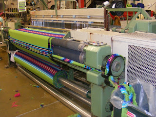
We took the 45-minute tour of the factory. The wool is actually dyed in a different place, then shipped here. It is then spun into thread, which is steam-heated, and then wound onto large bobbins. Bobbins (seen at left) are strung onto looms, which are now computerized, and the patterns are programmed in. Many of the patterns are designed by Native American artists, often based on traditional designs.

Once the wool is woven, it is inspected. The highest quality wool is made into blankets, shirts, and other clothing items. The fabric is also used to create pocketbooks, CD holders, personal organizers, key chains, notebook covers, and a large variety of other products. (Even lunch bags. I now own one.)


Very little of the weaving is wasted, our guide told us. Even the trimmed ends are sold to people who make rag rugs and other items out of them. At right is a machine that trims the edges of the weavings. The strip of trimmed rug is being wound onto a roll at the far right of the picture.


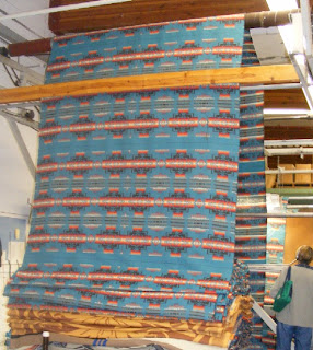
At left is a finished rug that has been hung up for inspection. Someone actually examines it both visually and by feel to grade its quality. First quality weavings will go on to be rugs, blankets, and clothing. Lesser quality weavings are also made into items, but are sold as seconds.


I'm not sure how well this video will play here, but I did get a shot of an actual machine weaving.


After finishing at Pendleton Mills, we moved on to the Pendleton Underground Tour. This literally takes you under the streets of the city, and displays rooms that span 70 years of local history. Saloons, a speakeasy (that later served as a bomb shelter), a bathhouse, the dwellings of the Chinese immigrants who came to serve as builders, applejack stills, and meat markets can all be seen in the rooms on the tour.


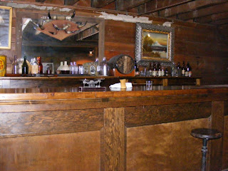
At left is one of the saloons. The guide explained that miners in the area often paid for drinks with gold dust, which would be weighed on the small scales that you might able to see in the center of the picture. The barkeep would pinch out the dust, put it on the scales, and weigh it.


As the evening continued, the scale would get further and further away from the bag of dust, and some of the dust would end up on the bar. This continued until closing, when the barkeep would sweep all the dust into a pile, add water, and then pan it to extract the gold, thereby making himself some pretty hefty tips!


At right is an ice cream parlor, which operated in the 1920s and 30s. Customers could enjoy a treat here that few could have at home, and the temperatures in the Underground kept everything cool.


At left is a picture of a walkway in the Chinese section of the
underground. The Chinese came to work on the railroads and for other tasks, but were not allowed above ground after dark. Our guide told the story of one fellow who was walking the streets after dark, and was shot and killed by a cowboy. The only thing the cowboy was charged with was discharging a firearm inside the city limits.

Being inventive folks, the Chinese knocked down walls of the underground rooms to form "sidewalks" that led from one area to another. Light came through glass set in the sidewalk above, and from lanterns lit and hung in the underground itself. You can just see one lantern in the picture to the left, just inside the window.


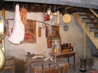
Another business that benefited from the chilly temperatures below the street was a butcher shop. Meats could be cut up and stored in underground pits for several days before being sent to the shop at street level.


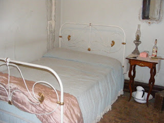
We did go above ground to view the Cozy Rooms, one of the 18 brothels in the city, which also doubled as a perfectly legitimate hotel, depending on which rooms you had booked. At left is a room used by one of the "working girls" of the Cozy Rooms. We also saw the madam's rooms, the chapel (yes, really, they had a chapel for Sunday services for the girls!), and the kitchen where maids prepared meals for girls.


Our third stop was the Tamastslikt Cultural Institute's Museum, located on the grounds of the Wildhorse Casino. The exhibits traced the 10,000 year history of the Cayuse, Umatilla, and Walla Walla tribes. They are part of the Plateau Culture, which contains elements of the Plains Indians and the Northwest Coast Tribes, plus some characteristics unique to this area.

Their stories follow a familiar pattern: both trade and conflict with other local tribes, until the European Americans discovered them (courtesy of Lewis and Clark's expedition). The local Native Americans then traded and fought with the newcomers, dealt with missionaries, and finally were forced to give up much of their land. They are now an independent entity, and are working to get their land back.

This was one place where photography wasn't permitted.

Tuesday, May 3, 2011

Oregon, Part I

This is one of the longest train trips we've ever done. Picked up Amtrak in Syracuse. For once, the waiting area was crammed with people. A bowling tournament had just finished, and the players (mostly middle-aged and older women) were on their way home. Most seemed to live in Illinois and Wisconsin, so the train was full. Good thing we had room reservations....

From Chicago, we took the Empire Builder west, and that's when things really got interesting. We were five hours late at one point. Flooding along part of the track forced us to take an alternate route. Also, some clown decided he just *had* to smoke on the train. The staff told him that was forbidden by federal mandate (not to mention common decency -- c'mon, we all have to breathe that air!). He ignored them and lit up. The train stopped at the next railroad crossing, the staff called the local police, and they tossed the offender off the train.

Below is a video and three pictures shot from the train window, to give you an idea of the landscape.


We spent two nights and most of two days riding across the upper U.S. One of the unique aspects of train travel are meals. You're seated with however many people are needed to fill a table, so you often end up sitting with people you've never seen before. My dining companions on this trip included two women traveling to Alaska by way of Texas (don't ask -- they had it all worked out to their satisfaction, and that's what counts), and a young man from England traveling the U.S. and Canada before going off to college. (And the absolute last thing he wanted to discuss was the recent Royal Wedding. Can't say that I blame him.)

With a lot of effort, the engineer cut our late time down to three hours. So we pulled into Portland, Oregon at 1 p.m. instead of the 10-something a.m. we were supposed to have. Rented a car, fired up Ethel (our friendly GPS) and headed out to Pendleton, Oregon, where we are currently.

Presently reading: Extremes, by Kristine Katheryn Rusch. It deals with a murder mystery on the moon, and is part of the author's Retrieval Artist series, about a detective who finds "Disappeareds" -- people who are given new identities because they've broken the laws of alien races, often by accident. This is a re-read for me, but I like the series. I've finally gotten it in e-book format.


Warning: my laptop has developed a virus. I'm hoping to find someone in Portland, Oregon willing to look at it and give a good cleaning, if possible. If not, I won't be able to upload pictures, although I will probably still be able to type posts. (Many hotels offer a "business center" with computers for travelers.) If necessary, I will post the text, then edit later to include pictures once I'm back up and running. Stay tuned.