Tuesday, May 29, 2012

Colorado, Part 8

Durango and Silverton were two of our final touring destinations.  They are linked not only by road, but by rail with what's known as a "narrow gauge" track.  Mom and Dad rode the train from Durango to Silverton and back, while I took a jeep ride into the mountains around Silverton to explore ghost towns, streams, and mines.  But first, some of the scenery on the bus ride out to Silverton.


Much of the scenery was like this.  These are the San Juan Mountains, by the way.


This is shot out the bus window at the road we would be riding in another minute or so.  Much of it was again twisty and winding.  I'm convinced that the state motto is actually: "Colorado -- where guardrails are for wimps."
Straight down as we round a curve.  Mom had originally planned for us to drive this road to Durango, but chose another route after she found out about the lack of guardrails.


The bus that carried us to Silverton.  The company is called Mild to Wild, and they offer several package tours coupled with the train ride.

And this is the "jeep."  Actually, the company did have a jeep-like truck that they were supposed to take us around in, but when our bus driver's brother started it up that morning, he discovered someone had pour sugar in the gas tank.  So we drove around in a couple of alternate vehicles.


A rock-crusher built into the side of a mountain.  Stone containing metal ore was dropped down this set of stairs, breaking the stone up for easier extraction of the gold, silver, or other metal.  The stone was then shipped to Durango for processing.  The technique apparently couldn't be done in Silverton -- the altitude was so high that fire couldn't be made hot enough to melt the ore.


A long, long stream of waterfalls.


One of the ghost towns in the area. 


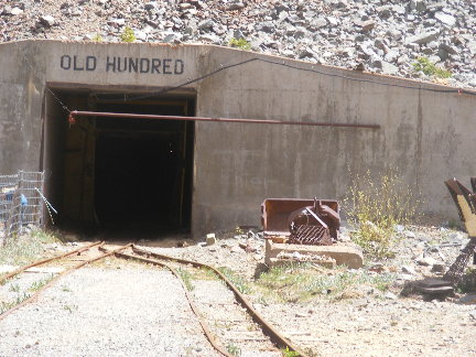
Area gold mine.  You could take a tour and visit a small exhibit on how gold and silver are mined.  There are still a number of mines in the area that could be worked, but people have a hard time getting permits because of environmental constraints.

People on the jeep ride with me thought that was terrible and the government shouldn't be allowed to do that.  Sorry, folks, but I'm with the EPA on this one.  My clean drinking water trumps your mineral rights.  Or it should, anyway.


I rode from Silverton back to Durango on the same train my parents took.  They got the luxury accommodations.  I got to travel coach, since I was only riding one way.  This is my car, from the back.


If you didn't mind the wind, you could also ride in the open observation car.


Mom and Dad "de-train" in Durango.


Much of the rest of the trip was shopping and traveling to different locations on our way back to Trinidad to catch the train on Friday evening.  We were concerned about the 45-minute wait at the "station" because there really wasn't a station.  It's just a loading platform and parking lot right now.  (Apparently it's just been upgraded.)  However, there was a sort of shelter at one end of the platform, so we could get out of the wind and sun.

Also, for the record, I picked up four Christmas gifts on this trip.   :-)

And now for a our last "wave," to Jonathan and Cheryl at the bank:


And that's it, until the next trip in September.  Tune in for yet another jaunt to Gettysburg, PA.


Monday, May 28, 2012

Colarado, Part 7

May 22, 2012

Mesa Verde National Park roads seem designed to frustrate people.

We drove 15 winding, twisty miles over mountains to get to the visitors' center and our tour bus.  It's got to be the longest 15-mile drive on the face of the Earth.

Mesa Verde includes 80 square miles of Anasazi cities, inhabited in the 1200s. The word "Anasazi" means "ancient enemy" in the Navajo language.  Although there's been a movement to change the name to something a little more accurate, most of the suggestions have been unwieldy.  Plus, a number of tribes are weighing in on the name change, and can't seem to agree on one.  So our guide used "Anasazi" throughout our tour.

Many of the cities look like the one on the right, tucked under an overhang called an alcove.  They consist of round rooms called kivas, and square homes, many with towers.  Kivas were the rooms in which religious ceremonies were held.  They were also sometimes used as dormitories when no ceremonies were being held.

Our tour was offered through Aramark, a lodge in the park itself, and lasted over three hours.  Our guide took us around to view several sights, with two stops to get out and talk about the culture of the Anasazi. 

At left is our tour guide talking about the yucca plant.  It was (and in some cases still is) used as a source of food, fiber for weaving, the basis for soap, and the soles of sandals.

Our guide also talked about the juniper tree, which is used for a variety of items, including building materials, firewood, food, and decoration.  


 At right is a double-tier city.  Many of the sites are off-limits to visitors, but we got to actually walk into Cliff Palace, one of the largest of the ruins.  It is pictured below.

The cities are made of stone bricks mortered with clay mud.  Most of the cities seem to have been building in a 30-year period.  The Anasazi originally lived on top of the mesas, and then in the early 1200s, began building cities in the alcoves.  Theories about what caused the moves include greater access to water supplies, protection from enemies, and shelter from increasingly poor weather.

Left: Cliff Palace.  Our guide for this was actually a National Park Ranger.  The site is not even remotely handicapped accessible -- you have to be able to climb down 130 steps (some metal, some stone), and up three ladders (about 10 feet long).

Plus the atmosphere is much thinner here, as we were at 7000 feet.  (Sea level is around 5000 feet.)

Still, if you can made the trek, you can actually walk around the plaza that connects the houses and kivas.
At right, if you look closely near the bottom of the picture, you can see a series of logs protruding through the wall.  These logs make up the wooden floor inside the building.  They were cut with hand-axes, giving them a "gnawed" look on the ends.  Several of the houses had more than one level; the tallest building were four stories high.

When you stand next to the doorways of the houses, you realize that the average height of people back then was under 5 feet tall.  Our guide mentioned that that seemed to be pretty universal among people living in the 1200s, no matter where on Earth they lived.

For many years, there was a mystery surrounding the disappearance of the Anasazi.  By the end of the 1200s they had all left the area.  Theories included being chased from the area by enemies, or even alien abduction.  But anthropologists noticed similarities between Anasazi culture and the cultures of the Pueblo and Hopi Indians.  It's now know that the Anasazi moved to a different part of the Southwest and continued their civilization elsewhere. Their descendents are still living on those areas today.


Saturday, May 26, 2012

Colorado, Part 6

Saturday, May 19th

Not a lot to report here.  I spent part of the day going whitewater rafting on the Arkansas River, through a section rated as Class 3.  (No large waterfalls, and a better-than-average chance of surviving the experience.  :-) )  I have no pictures to post, since my camera isn't waterproof.  My trip was done through Performance Tours, and lasted a couple of hours.

Sunday, May 20th

We attended church last night, but went back this morning for a quick "wave" to Barbara and Gary Vining:


Sunday, May 20, 2012

Colorado, Part 5

Pikes Peak, and the cog railroad that goes to the top.  (Thank goodness.  I'd hate to have to hike that....)  (And, for the record, people don't just hike it, they run marathons up and down it.  No joke.  The record to the top and back is just over three hours.  You can also drive to the top.)

Pikes Peak is the inspiration for Katharine Lee Bates' well-known song "America the Beautiful."


One of only a handful of cog railroads in the United States, this is the longest and climbs the highest.  As you can see in the picture on the left, there is a "third track" in the center.  This is where the gears on the underside of the train connect, and literally pull the cars up the hill.  (The two outer tracks are for balance.)

This railway was started in 1889, after a tourist named Zalmon Simmons road to the top of the mountain on a mule, but decided there had to be an easier way to get there.  He raised over $1 million to build the first set of tracks, which were used by steam engines.  Of the six original engines, only one still operates on special occasions.  The first diesel cog engine was used in 1938.

Here's the actual train itself.  The trip up and back takes around three hours.  You spend half an hour at the summit, where there's a gift shop and a set of rest rooms and observation platforms.  The conductor gives information about the vegetation, local activities, and the history of the railroad as you ride to the top.  There's often a 30- or 40-degree difference in temperature between the bottom depot and the top.  Also, it's a good idea to bring along a can of oxygen (sold in the gift shop) if you or someone in your party has trouble breathing.  After all, you're going up to over 14,000 feet above sea level -- air's pretty thin up there.  (The poor fellow across the aisle from us had such a hard time adjusting that he threw up when we reached the top.)  It's not unusual to need to sit down and drink something for the first 10 minutes you're there.  Also, because of the change in atmosphere and air pressure, your voice changes.

Below are some of the sights we saw on the way up.


Some of the trees look tilted.  Actually, they're growing perfectly straight -- we just rode up at an angle.  And that line across the middle of the picture is the top of our window.

Below is a video shot at the top.  The wind covers up a lot of other sounds, so my narrative may not be audible at all times.  Basically, it's about 40 degrees F, with a wind-chill factor of 20 degrees.


And below is another of Mom's "waves", this time for Jeff.  We're at the summit of Pikes Peak.


Thursday, May 17, 2012

Colorado, Part 4

The United States Air Force Academy, located just outside Colorado Springs, was today's stop.  There are six places to visit for members of the general public (and more if you have an active military ID, apparently), and we started at the Visitors' Center and museum.


Along the Center's walls are displays showing cadet life.  There is one board each for Freshmen, Sophomore, Junior, and Senior years, outlining what is to be learned and what major tests must be passed.  The picture at right shows the Sophomore board.


Interior displays include the various clubs cadets can join, designs for the Cadet Chapel (more on that below), and a falconry display.  The falcon is the Academy's official mascot.  At left is a hand-carved falcon donated to the Academy.


 At right is the schematic of the Cadet Chapel, a distinctive building that houses places of worship for Christian, Jewish, and Buddhist students.  (There is both a Protestant and a Roman Catholic section available.


At left is the outside of the Chapel, the Protestant section on top, and the other sections on the bottom.


At right is the interior portion of the Protestant Chapel.  It's difficult to see in this shot, but there is a large, thin cross hanging from the ceiling.


Sections of the stained-glass panels highlighting the windows.  The panels continue on to the ceiling.


The altar.


The Catholic Chapel (pictures of the current Pope were kind of a give-away when you walk in.)


One of the Stations of the Cross.  It appears to be Jesus comforting the women of Jerusalem.  Sections of all the chapels were roped off and closed to visitors, but there were still plenty of items to photograph.


The front of the Jewish Chapel in the basement.  The room is round, and located in the center of a small area behind the Catholic Chapel.


The small Buddhist Chapel.  Visitors are asked to remove their shoes before entering, but the entire room was roped off, so it was kind of a non-issue.


A view of the campus from the Chapel steps.  Over 1200 students enter the Academy each year.

Colorado, Part 3


May 16th:

We had planned to visit Rocky Mountain National Park, but there were apparently some concerns about the roads, so we skipped that and visited Idaho Springs, noted for its gold, silver, and metal mines.  There is a small museum and visitors' center in town, and we stopped there first. 

Because of "orphan mines", the area water supply has been contaminated, and the entire back of the museum is a display of clean-up efforts.  Partnerships between local groups, mining operators, and the federal government have been formed.  Land has been reclaimed, and mines sealed to prevent run-off of dangerous metal into the local water.  At right is a display of "before" and "after" in one area of the county.

During our visit, we were joined by a group of school kids, most of whom had no interest in the museum, and were either playing with items in the gift shop, or playing hide-and-seek among the displays.  Mom finally complained to the owner, and the kids were brought under control by their teachers.  We've been with school groups before, and many were well-behaved, so we know it can be done!

We then walked the local historic district, and did some shopping.  I picked up a couple items for myself, as well as three Christmas gifts. 

We returned to Black Hawk to our hotel room for the night.  Above is a picture of the elevator floor, just for everyone's viewing amusement.  Mom had the most excitement at this stop.  She played a game of Roulette, and won $3.  She also tripped on the sidewalk on a walk around town, and now has a number of bruises.  No broken anything, though, and she's doing pretty well.


Wednesday, May 16, 2012

Colorado, Part 2

So, it's off to Black Hawk, small city of casinos.  But first, we're stopping at Celestial Season's Tea Factory for a look at how tea is make and the ingredients found.

Celestial Seasonings teas are found in most grocery stores around the country, but all the tea is made in Boulder, Colorado.  The herbs, flowers and leaves that make up the tea, however, come literally from all over the world.

The Virtual Tour here is a super-simplified version of the tour we took.  Unfortunately, pictures couldn't be taken on the tour, so this is the best I could do.

I can, however, show you some of the pictures of the cafe, which included displays of the process, as well as four cases of seriously cool teapots and cups, and pictures of the art produced for boxes of the various flavors of tea.


At left is one of the display panels, detailing some of the ingredients used in various flavors, and where they' re grown.  These include chamomile, peppermint, vanilla, lemongrass, blueberries, and honey, to name only a few.

The tour of the factory began with a short video about the teas, the people who develop the different blends, and the farmers who produce the ingredients.  Then everyone donned hairnets, and a few of guys "beard nets" (yes, really!), and we walked into the factory.


 At right is one of the teapots on display in the lobby.

Our tour guide explained that most teas had to be blended, and showed us the large plastic "tubs" that shake and roll the mixtures.  She then walked us through the storage area, where we could see boxes and bags of different ingredients.

One whole room is devoted to the mints -- peppermint, spearmint, and wintermint.  This is because mints have such a strong odor that they would overwhelm all the other scents if not kept separate. 
 It's hard to see the full teapot at left because of the camera angle, but all of those "branches" are actually part of the handle or feet.  I seriously want one of these.  (It stood over two feet tall.)

We continued on the tour, and ended up at the final step in the process: the machine that stacks the packed cartons of tea for shipping.  Then we continued on around the room, looking at the boxing machine, the area in which the tea is actually placed in teabags, and the conveyer belts that move everything along.   The full tour took about 30 minutes, and ended up, of course, in the gift shop.


At right are two of the paintings of art produced for the tea boxes.  Some of the art was labeled with the name of the flavor it was produced to represent, some was not.


While waiting for the tour to start, you have a chance to sample some of the teas, including green and red tea flavors, "zingers" (which have a distinct "zip" to them), and chilled flavors of iced teas.  You also picked up your "tea-ckets" (a variation on the word "ticket"), which showed that you belonged on this particular tour.  Each "tea-cket" was a packet containing three teabags of a particular flavor.  We had peppermint.


In the video theater was the Sleepytime Bear, the official representative of Celestial Seasonings.  Of course, Mom had to have a photo op.  And the staff was kind enough to supply Dad with a wheelchair, so he didn't have to stand through the whole tour.  (No pictures of that, though....)


Once finished with the tea factory, we stopped briefly at Into the Wind Kites and Toys, at the request of my friend David.  This was something of a mistake.  Mom's rubber duck collection suddenly grew by about half a dozen members....


Just to give you an idea of part of the store's inventory:


Colorado, Part 1

Arrived in Trinidad, Colorado this morning, rented our car (well, it's more like a mini-van, but that's the only thing they had available -- I'll post pictures later), and drove out to Colorado Springs to tour the Garden of the Gods.  (Another good website here.  Lots of photos.)

This is a drive-though park, with no admission fee, easy walking trails, and dozens of red and white rock formations.  Some can be seen from the road, others only from the trails.


The formations made this area a landmark, not only for the Ute and other local Native Americans, but also for people moving west to prospect for gold.  It was dubbed "The Garden of the Gods" in 1859 by a young man named Rufus Cable, who thought it too majestic to be a mere "beer garden", as one of his friends called it.

 At right, if you look closely, you can see the red and blue of a rock climber.  Several people were climbing this afternoon, which is allowed as long as you have the proper equipment. 


At left is one of the rock formations along the Perkins Central Garden Trail.  This one can only be seen if you walk the footpath.  The stones were formed millions of years ago as sediments settled to the bottom of the ocean that covered this region at that time.  Later, the rock was pushed upward by geological forces.  Wind and water wore the softer parts of the stones away, leaving the formations you see here.


Several stones, also along the Perkins Trail.  More information on the history of the area can be found here.


The Balancing Rock.  Weather and water have eroded the stone's sides and base.  (And no, there are no blue shapes on it -- that's a camera issue with the sunlight's angle.)


Mom promised people "waves" from various places along our trip, so here's the first.  Please note that none of us are providing the laughter you hear in the background before the clip ends; my camera's microphone just picks up everything.